")
")


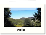
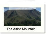
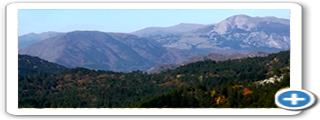
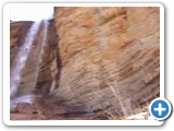
The Voio Mountain, from which the homonym province took its name, consists of four individual mountains with particular natural beauty. Thus, it is not a homogenous mountain, but a cordillera with direction from the North to the South, just like Pindos. Its length and width reach 45 and 30 Km, respectively. Voio is one of the most forested Greek mountains, having trees in an area which covers 80%. The Ancient Greek geographers define as Voio, the entire Pindos cordillera. The most distinctive component of this mountain is the number and the formation of its peaks. These characteristics owed their nature in the impressive geographical formulations. Its bed of rocks arrangement has a West to East direction which has as effect, bold cliffs at the western and smooth forest lands at the eastern parts. These facts made Voio a rare biotope for a variety of animals, such as wolves, deers, wild pigs and bears. Aliakmonas River and its most significant affluents (Pramoritsa, Velos, Venetikos and Sarantapororos Rivers), are spring from Voio.
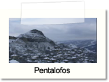
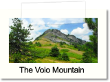
Voio consists of the main body with fascinating abundant vegetation. It starts to erect along the basin between Nestorio and Peykos villages of the Kastoria Prefecture. Then crosses the Kozani Prefecture and settles to the Grevena Prefecture. The main part of the mountain belongs to Kastoria district and there are not few who wrongly confuse it with Grammos Mountain, as Voio consist a mountain of its own, geographically and geologically. Its distinctiveness is that it comprises of two peaks of equal height; the ‘’Paliokrimini’’ (1812 m altitute) and ‘’Profitis Ilias of Zoupani’’ (1810 m altitude). The third higher peak is ‘’Petritsi’’ (1784m) and the fourth, the Pirgos of Kotili (1767 m). The entire crest of Voio’s main body, from Profitis Ilias at the North until the Pirgos of Kotili, constitutes the highest part of the mountain. It consists of numerous peaks with altitude greater than 1600 m, forming, in combination with Grammos Mountain at the West, the Srantaporos valley.
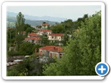
The second big part of Voio is the ‘’Ondria’’, which has vertical direction at the main body, intersects the mountain at the area north of Paliokrimini, ending at the Municipality of Orestida, a few kilometers before the towm of Kastoria. The highest peaks are the ‘’Megali Otra’’ (1589m) and the ‘’Mikri Otra’’ (1530 m), where the landscape is considerably strange due to the flat platform. In this area, where the vegetation is lush, the majority of ‘’Kastanoxoria’’ are located.
In parallel with the main body, starting from the area of Eptaxori and eventuating at Dotsiko village, Taliaros Mountain is erected full of vegetation and mixed forests. In this area, Voio meets the bulge of ‘’Smolikas’’ at the south and Grammos at the north. Its highest peak is ‘’Thanasoulas’’ (1537m), almost beneath the ‘’Profitis Ilias of Zoupani’’ peak. Paliomagero affluent springs eastern of Taliaros Mountain and Veneticos River from its west.
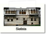
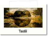
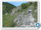
Finally, the lower part comprises of the successive and whistle palisade of Polikastano- Aygerinos-Tsotili with numerous peaks which exceeded 1000m. Here are formed the main valleys of Pramoritsa and Velos Rivers and the abundant alpine and riparian forests which are interchanged to grasslands. The majority of the mountainous and semi- mountainous villages are located in this area. This alpine network has irregular direction, however, generally follows the way of the main body, concluding at the Grevena Prefecture.
Voio consists of the main body with fascinating abundant vegetation. It starts to erect along the basin between Nestorio and Peykos villages of the Kastoria Prefecture. Then crosses the Kozani Prefecture and settles to the Grevena Prefecture. The main part of the mountain belongs to Kastoria district and there are not few who wrongly confuse it with Grammos Mountain, as Voio consist a mountain of its own, geographically and geologically. Its distinctiveness is that it comprises of two peaks of equal height; the ‘’Paliokrimini’’ (1812 m altitute) and ‘’Profitis Ilias of Zoupani’’ (1810 m altitude). The third higher peak is ‘’Petritsi’’ (1784m) and the fourth, the Pirgos of Kotili (1767 m). The entire crest of Voio’s main body, from Profitis Ilias at the North until the Pirgos of Kotili, constitutes the highest part of the mountain. It consists of numerous peaks with altitude greater than 1600 m, forming, in combination with Grammos Mountain at the West, the Srantaporos valley.
The second big part of Voio is the ‘’Ondria’’, which has vertical direction at the main body, intersects the mountain at the area north of Paliokrimini, ending at the Municipality of Orestida, a few kilometers before the towm of Kastoria. The highest peaks are the ‘’Megali Otra’’ (1589m) and the ‘’Mikri Otra’’ (1530 m), where the landscape is considerably strange due to the flat platform. In this area, where the vegetation is lush, the majority of ‘’Kastanoxoria’’ are located.
In parallel with the main body, starting from the area of Eptaxori and eventuating at Dotsiko village, Taliaros Mountain is erected full of vegetation and mixed forests. In this area, Voio meets the bulge of ‘’Smolikas’’ at the south and Grammos at the north. Its highest peak is ‘’Thanasoulas’’ (1537m), almost beneath the ‘’Profitis Ilias of Zoupani’’ peak. Paliomagero affluent springs eastern of Taliaros Mountain and Veneticos River from its west.
Finally, the lower part comprises of the successive and whistle palisade of Polikastano- Aygerinos-Tsotili with numerous peaks which exceeded 1000m. Here are formed the main valleys of Pramoritsa and Velos Rivers and the abundant alpine and riparian forests which are interchanged to grasslands. The majority of the mountainous and semi- mountainous villages are located in this area. This alpine network has irregular direction, however, generally follows the way of the main body, concluding at the Grevena Prefecture.